Welcome to the San Pablo Avenue Bus Lanes and Bike Lanes Project - Community Input Website!
This website provides information and seeks your feedback on the San Pablo Avenue Bus Lanes and Bike Lanes Project, which proposes safety and transit improvements along San Pablo Avenue in Oakland, Emeryville, and south of Heinz Avenue in Berkeley. To learn more about all of the efforts underway to improve the San Pablo Avenue corridor, including north of Heinz Avenue, please go to www.alamedactc.org/sanpablo. These projects are being led by the Alameda County Transportation Commission, along with support from the partner jurisdictions of Berkeley, Emeryville, Oakland, AC Transit, and Caltrans.
For other languages, please use the dropdown menu on the top right corner of the page.
该网站提供有关拟议项目的行人安全、公交车道和自行车道改进的详细信息,以及为该项目提供意见的方法。
Para otros idiomas, utilice el menú desplegable en la esquina superior derecha de la página.

We Need Your Input!
The community input website comment period has closed. If you have questions or comments, please contact the project team at sanpabloave@alamedactc.org.
Through this community input website, you can share your thoughts on the project in two steps:
(1) Please provide your feedback about specific changes using the community feedback tool; and
(2) Please also complete a brief anonymous questionnaire to help us know how you use San Pablo Avenue and help us make sure we're reaching people throughout the community.
Scroll down this page to learn more about the proposed improvements to San Pablo Avenue.
We appreciated your time and input!
For more info about the proposed project and other ways to provide input, please visit www.alamedactc.org/sanpablo.
For further language assistance, questions, or to receive future email updates about the project, please contact sanpablo@alamedactc.org or call 510-208-7490.
如果你想用另外语言,请在右上角更改。 有关拟议议项的更多信息,请访问 Visit the San Pablo Avenue Corridor Project Page
www.alamedactc.org/sanpablo.
如需语言帮助、有关该项目的问题或想未来接收电子邮件新闻,请发电子邮件至 sanpablo@alamedactc.org 或致电 510-208-7490.
Para otros idiomas, utilice el menú desplegable en la esquina superior derecha de la página. Para obtener más información sobre las mejoras propuestas, visite www.alamedactc.org/sanpablo.
Para obtener más ayuda con el idioma, preguntas o recibir futuras actualizaciones por correo electrónico sobre el proyecto, envíe un correo electrónico a sanpablo@alamedactc.org o llamar 510-208-7490.
Project Summary
The proposed Bus Lanes and Bike Lanes Project would make bus travel more reliable, create new and safer bicycle connections, and make crossing San Pablo safer for people walking and biking.
Proposed improvements include:
- Intersection safety improvements: Crosswalks, street lighting, crossing signals and flashing lights known as beacons. Other improvements at crosswalks include curb extensions to provide shorter street crossings and pedestrian refuge islands that provide safe space in the road median. Wheelchair-accessible curb ramp upgrades and audible pedestrian signals at intersections would improve accessibility for people of all abilities.
- Dedicated bus-only lanes: Creating bus-only lanes to make buses faster and more reliable. Autos may enter the bus lane where needed to make right-turns to streets and driveways.
- Protected bike lanes: Creating protected bike lanes separated from traffic by curbs.
- Streamlining bus stops: Consolidating some Local (72, 72M) bus stops, adding more Rapid (72R) bus stops, and making bus stop spacing more consistent to enhance bus reliability. In some cases, this would change the location of some bus stops (see map for details).
- Bus platforms: Waiting areas, or boarding islands, would be constructed at bus stops with sidewalk-level bike lanes between the stop and sidewalk. New and/or improved amenities, such as new bus shelters, would be provided at all stops. This requires tree removal and replacement in some locations.
To make these improvements possible, the project would repurpose one of the traffic lanes in each direction for buses and eliminate most parking along San Pablo Avenue. This project includes careful consideration to parking alternatives. Most parking and loading activity would be moved to side streets and existing off-street parking lots. A limited number of loading and short-term parking spaces would remain where necessary on San Pablo Ave.
Existing conditions and proposed project improvements

Read on to learn more about specific types of project improvements.
Bus Lane and Bus Stop Changes
The project would improve bus travel times significantly, on average reducing four to ten minutes per trip (20% to 45%) during peak commute periods.
Click on the tabs below to learn more about the proposed bus lane and bus stop changes.
The project proposes a red dedicated bus-only lane between 20th Street in downtown Oakland and just north of Ashby Avenue in Berkeley. The project also considers strategies to limit illegal use of the bus lane by personal vehicles such as bus lane separation.
There are three types of bus lane separations being considered for the project. The specific type will be determined by multiple agencies including Caltrans and the cities’ fire departments. The three types are striping only, plastic (bollards or deflectors), and raised concrete curb. Each type of bus lane separation is described and illustrated below.
- Striped Buffer: A painted white stripe with no raised barrier used alongside a red painted bus-only lane. This option would allow for the easiest access for all users, including emergency services. It would not provide any physical barrier against vehicles using the lane illegally.
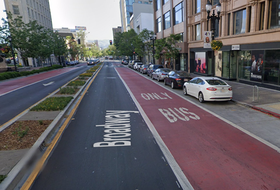
- Raised, Plastic Barrier: A small, raised plastic barrier with raised plastic posts alongside a red painted bus-only lane. This option would provide a more substantial separation than just paint, helping to deter illegal use of the bus lane. Frequent small gaps would be provided to allow for emergency vehicles access. Larger gaps between the raised barriers would be provided at all driveways, loading zones, and turning locations.
- Raised, Concrete Barrier: A small, raised concrete barrier would act as a buffer alongside the red painted bus-only lane. This would be the most substantial separation of the three options. Plastic posts could also be placed on top of the concrete to make the barriers more visible. Emergency vehicles would be able to drive over the barriers when needed, but they would be too large for most autos to comfortably drive over. Larger gaps between the concrete barriers would be provided at all driveways, loading zones, and turning locations.
The project would consolidate some Local (72, 72M) bus stops, add more Rapid (72R) bus stops to make bus stop spacing more consistent and enhance bus reliability. In some cases, this would change the location of some bus stops. The 72R Rapid stops would serve all remaining stops, so there would be more Rapid bus stops but fewer Local stops than today. See all of these changes on the bus stop map below.
Bus stops would be enlarged and include new amenities, such as lighting, shelters, and benches. Other improvements near bus stops would include a sidewalk-level bike lane between the bus stop and sidewalk.

Example Bus Boarding Platform

Intersection Safety Improvements
Intersection safety improvements are proposed throughout the corridor. Examples of improvements include:
- Realigning crosswalks to be more direct
- Introducing curb extensions to shorten crossing distances
- Proposing mid-block crossing pedestrian refuge islands where possible
- Installing flashing beacons and flashers for select uncontrolled intersections
- Updating curb ramps to meet ADA standards
A number of pedestrian crossings without a signal along San Pablo Avenue are proposed for improvement with traffic signals or flashing traffic warning lights. High visibility and placement of crossings would also be considered to make crosswalks more accessible and safer. Other proposed improvements at some crosswalks include installing raised concrete islands that serve as waiting areas and shorten street crossings (see specific locations in the interactive map).
- New or improved curb ramps
- New or improved concrete “pedestrian refuge” median islands to make crossings safer and more comfortable
- New or improved corner sidewalk extension “bulbouts” to shorten crossing distances and make pedestrians more visible
- New crossings with traffic signals or flashing beacons
- Improved crosswalk striping to make all crossings high-visibility and to set cars back from crosswalks
- Accessible pedestrian signals (APS): a device that provides audible tones and vibrotactile surfaces that announces the WALK and DON'T WALK intervals at signalized intersections. This improvement is proposed for all intersections that receive signal upgrades.
- New or upgraded pedestrian lighting at some locations
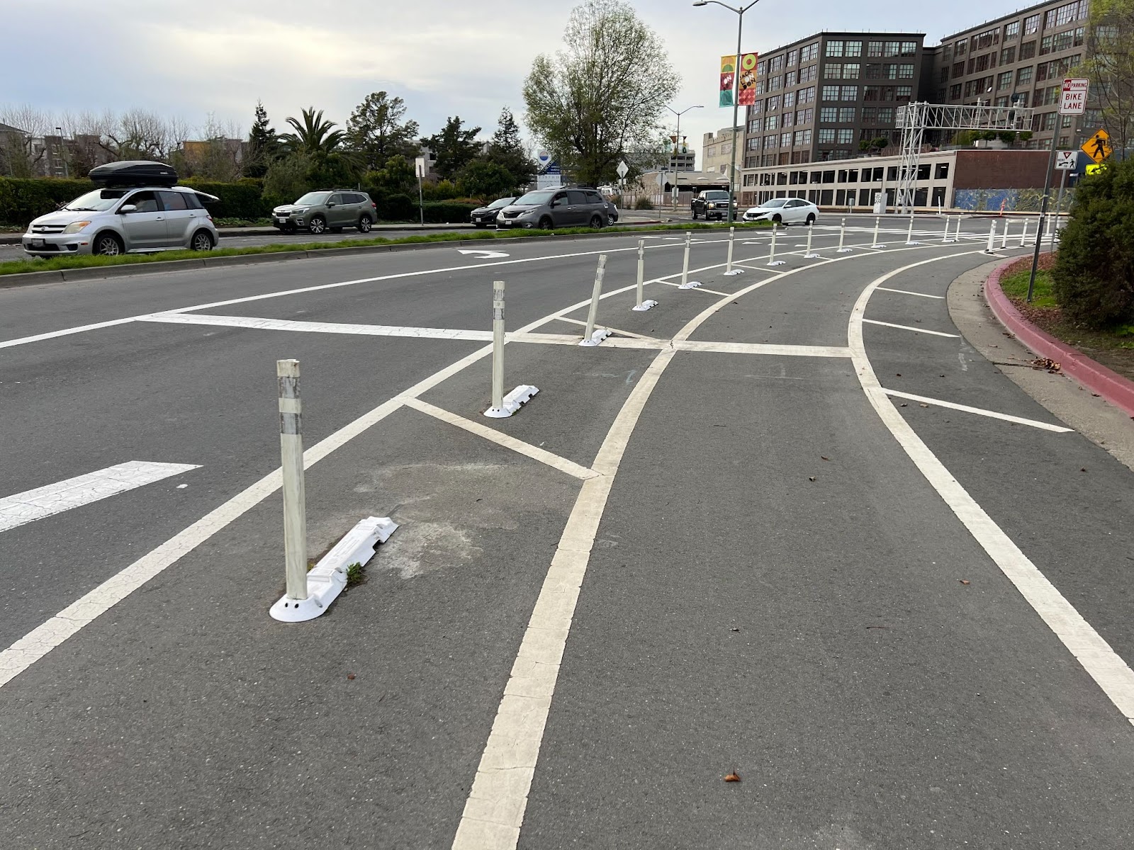
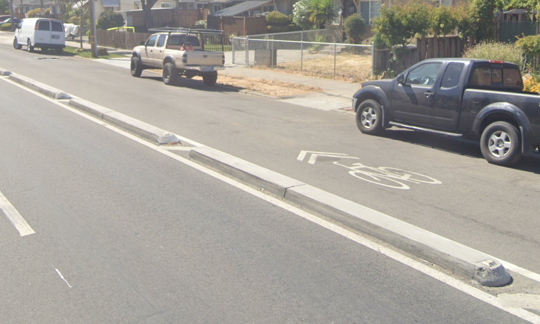
The project provides separated bike lanes between 20th Street in downtown Oakland and Heinz Avenue in Berkeley. The bike lanes would be vertically and horizontally separated from the bus and auto lanes, where possible. At locations with other usages such as driveways, intersections, and loading zones, different strategies are proposed to create space for various modes in order to protect bicyclists and pedestrians. Additionally, continuous, buffered bike lanes and improved intersections would enhance the existing bike lanes and markings on San Pablo Avenue between 16th and 20th Streets in downtown Oakland. Buffered bike lanes are separated from other lane types through use of a paint stripe, a vertical barrier, or raised curb.
Vehicle Parking, Traffic, and Access Changes
Click on the tabs below to learn more about proposed changes.
New dedicated bus lanes and bike lanes would require eliminating most parking spaces along San Pablo Avenue. Most on-street parking and loading activity would be relocated to side streets or existing parking lots.
To provide alternative locations for business parking and loading, changes would be made to curb parking spaces on side streets adjacent to commercial properties. These changes would include:
- Creating new commercial or passenger loading (yellow or white curb) zones, including paratransit loading, where needed
- Installing limited-time parking (green curb) zones and/or parking meters on side streets to increase turnover and increase parking availability that would serve for businesses where parking is determined to be in highest demand
- Adding ADA/disabled parking (blue) spaces
As part of the project, new side street lighting would be installed to enhance the safety and accessibility of these side street loading and parking areas.
At each location that is commercial or multi-family residential and does not have access to off-street loading or front existing side-street loading spaces, (i.e., located further than 100’ from adjacent side street loading spaces), a loading zone would be provided on San Pablo Avenue. These would occur in lieu of the protected bike lane for a limited distance. At these locations, where there is active loading in the loading zone, cyclists may share the bus lane or walk their bikes on the sidewalk.
Locations of parking and loading changes are shown in the Interactive Map below. These changes have been discussed with San Pablo Avenue’s storefront community.
Below is an example of the loading zone on San Pablo Ave (at Murray St)

In this example of a commercial loading zone for adjacent storefronts, loading activity would occur along the curb where the bike lane would otherwise be. If the loading zone were unoccupied, a person biking would be able to proceed straight through the loading zone. If it is occupied by loading vehicles, cyclists may choose to navigate around it either by sharing the bus lane or using the bike ramp onto the sidewalk. Cyclists would need to dismount and walk their bikes while on the sidewalk where required by city ordinance and indicated with signage and markings on the sidewalk. At the end of the proposed loading zones, which are generally five to ten parking spaces long, cyclists would be able to return to the protected bike lane.
Removing one auto lane in each direction would result in increased congestion and up to 5% increase in travel time for drivers on San Pablo Avenue. Some cars would divert to alternative local streets to get to their destinations.
An estimated 5%-25% of drivers during the peak hours are expected to seek alternative local streets to complete their trips due to congestion.
- 5% morning congestion hour (8-9 AM) for drivers traveling southbound.
- 15% - 25% in the evening congestion hour (5-6 PM) for drivers in both the northbound and southbound directions. Drivers traveling southbound may opt to divert at streets such as University Avenue and Ashby Avenue before reaching the start of the bus-only lane. Northbound drivers divert at Martin Luther King Jr. Way, W Grand Avenue, and Market Street.
Streets parallel to San Pablo Avenue such as Martin Luther King Jr. Way, Market/Sacramento Street, Mandela Parkway, Hollis Street, Shellmound Street, and Adeline Street are expected to see an increase in vehicle traffic. East to west running streets that intersect San Pablo Avenue such as Ashby Avenue, Alcatraz Street, Stanford Avenue, 40th Street, and W Grand Avenue may also receive additional traffic. However, traffic study has determined that increases to traffic congestion and travel times on these parallel streets will be minimal.
Turn restrictions and other auto access changes where San Pablo Avenue intersects some side streets are noted with this symbol ( )on the map
In some locations where existing driveways are unused, fenced off, or there are other entrances to the same parking area, closures are proposed to allow for more continuous bike lane protection and an improved pedestrian experience. All driveway closure locations are noted on the interactive map.
Improvement Renderings
Click on the tabs below to see 3-D drawings of five example locations along San Pablo Avenue that illustrate the improvements being proposed. Images include current conditions and proposed improvements and are draft proposals subject to city and/or Caltrans approval.
Thomas L Berkley Way (20th St.) and Martin Luther King Jr. Way is where buses turn and continue east along Thomas L Berkley Way to the 19th Street BART station and is the southern end of the proposed bus lanes on San Pablo Ave. The curb-protected bike (raised curb outside of the bike lanes) to the north would also transition here to buffered bike lanes (separated from the traffic lane with painted markings) continuing south to 16th St. The proposed design includes corner sidewalk extensions to narrow the intersection, shorten crosswalks, and slow down turning vehicles. A new pedestrian crosswalk is proposed on the north side of the intersection where crossing is currently prohibited. The design includes dedicated bike waiting spaces, and markings to guide bicycle movements across the intersection.
Looking North from Thomas L Berkley Way to Castro Street
Existing Conditions

Proposed Improvements

At Market Street, the proposed design would improve safety for all users. An extension of the sidewalk would be constructed at all corners to narrow the intersection, shorten pedestrian crossing distances, and slow turning traffic. All corners would also provide curb-protected or sidewalk-level bike lanes and waiting areas so people biking can safely connect between the new bike lanes on San Pablo Ave. and the existing bike lanes on Market St. The existing Line 88 bus stops would be relocated to new platforms with amenities including shelters. The northbound Line 88 platform would be shared with the new 72R, 72, and 72M platform and the southbound platforms would be close together for easy transfers. Turns from San Pablo Avenue to eastbound 30th Street would be restricted.
Looking North towards Market Street
Existing Conditions

Proposed Improvements

The proposed bike lanes on San Pablo Avenue would connect from Oakland and Emeryville north to the existing east-west Bicycle Boulevards on Russell St. and Heinz Avenue in South Berkeley. A two-way curb-protected bike lane (raised curb outside of the bike lanes) is proposed on the west side of San Pablo Avenue between Russell Street and Heinz Avenue to provide high-quality connections between the bike lanes on San Pablo Ave., Heinz Ave. and Russell St. A new traffic signal at San Pablo Ave. and Russell St. would allow people walking and biking to safely cross San Pablo Ave. At Heinz Ave., signal changes, left-turn, and No Right Turn on Red restrictions would allow people walking and biking to safely connect between San Pablo Ave. and Heinz Ave. The proposed bus lanes would end just north of Ashby Ave., so two traffic lanes would remain in each direction on San Pablo Avenue through the Russell St. and Heinz Ave. intersections.
Looking North from Russell Street to Heinz Avenue
Existing Conditions

Proposed Improvements

Looking North towards 57th Street and Stanford Avenue
Existing Conditions

Proposed Improvements

Looking North towards 40th Street
Existing Conditions

Proposed Improvements

Note: Bus Lanes and Protected Bike Lanes along 40th Street are to be implemented by separate project.
Remember to get involved!
You can share your thoughts on the San Pablo Avenue Bus Lanes and Bike Lanes Project in two steps:
(i) Please provide your feedback about specific changes using the community feedback tool below; and
(ii) Please also complete a brief, anonymous questionnaire to help us know how you use San Pablo Avenue and help us make sure we’re reaching people throughout the community.
Your input is very important to us and we appreciate your time!
If you are unable to load the Community Feedback Tool page, please refresh page or use a different browser. We apologize for any inconveniences.
-
Community Feedback Tool


